 精选c# ArcEngine93 实现实时显示测距结果功能.docx
- 文档编号:10469546
- 上传时间:2023-02-13
- 格式:DOCX
- 页数:19
- 大小:37.11KB
精选c# ArcEngine93 实现实时显示测距结果功能.docx
《精选c# ArcEngine93 实现实时显示测距结果功能.docx》由会员分享,可在线阅读,更多相关《精选c# ArcEngine93 实现实时显示测距结果功能.docx(19页珍藏版)》请在冰豆网上搜索。
精选c#ArcEngine93实现实时显示测距结果功能
c#+ArcEngine93实现实时显示测距结果功能
利用ArcEngine实现距离量测,面积量测的功能已很简单,相信众多的ArcGIS爱好者都能写.但单纯的实现功能总觉得欠什么.本人喜欢改代码,喜欢优化代码,在原有的功能基础上总喜欢"润色",使之更好看.前一整子在玩skyline时看到skyline的测距功能能实时显示量测的距离,于是联想到之前自己用C#+ArcEngine写的测距功能.何不也优化一下自己代码?
想到就做到.最近手有点痒,算练练手.
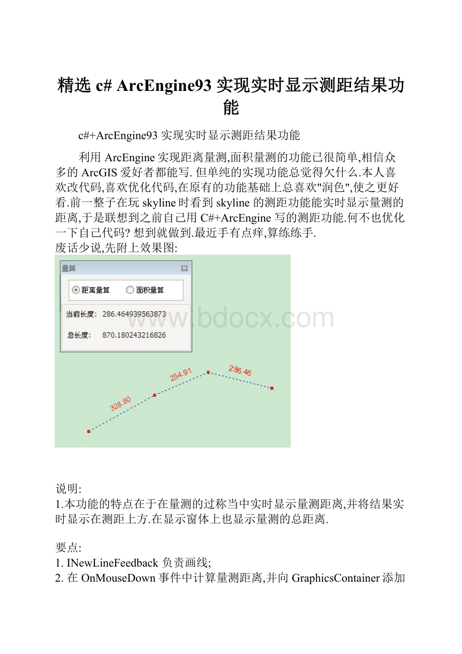
废话少说,先附上效果图:
说明:
1.本功能的特点在于在量测的过称当中实时显示量测距离,并将结果实时显示在测距上方.在显示窗体上也显示量测的总距离.
要点:
1.INewLineFeedback负责画线;
2.在OnMouseDown事件中计算量测距离,并向GraphicsContainer添加线和节点的Element;
3.在OnMouseUp事件中实时计算距离随鼠标移动后产生的新距离.
4.将节点,量测值,线的element都分别存入到节点组和轨迹线组(IGroupElement),即用IGroupElement同一管理这些element;最后将这些groupelement又添加到一个总的groupelement.这样做的目的在于好控制这些element,特别是启动新的量测或取消量测功能时可以控制这些element,而不必去用IGraphicsContainer.DeleteAllElements来清除这些element,使用IGraphicsContainer.DeleteAllElements会将所有的element删除.
5.量测值element为ITextElement,由于他停靠在轨迹线的上方,因此需要对量测值element进行一定角度的旋转,旋转角度由轨迹线的方向角决定.
6.绘制element之后的刷新问题也是比较重要的.刷新范围一定要控制好,太小了,添加的element显示不出来,太大了,浪费.(实在不好控制就刷新整个extent吧,呵呵)
核心代码如下:
1.TrackLine类
TrackLine
//=================================功能测距==========================
//描述:
实时显示测量距离,节点位置,总长度
//编程:
Jin 开发时间:
2009.8.10-2009.8.11
//特点:
实时计算量测距离.
//缺点:
由于采用element做为显示内容,地图进行放大缩小操作后并不能很好
// 控制量测值element和轨迹线element之间的距离间隔.
//===================================================================
using System;
using System.Drawing;
using System.Runtime.InteropServices;
using ESRI.ArcGIS.ADF.BaseClasses;
using ESRI.ArcGIS.ADF.CATIDs;
using ESRI.ArcGIS.Controls;
using ESRI.ArcGIS.Carto;
using ESRI.ArcGIS.Geodatabase;
using ESRI.ArcGIS.Display;
using ESRI.ArcGIS.Geometry;
using System.Windows.Forms;
namespace MhGis.GisTool.Pb_Toolbar
{
class TrackLine :
BaseTool
{
private IHookHelper m_hookHelper = null;
private INewLineFeedback m_NewLineFeedback = null;
private IPointCollection m_ptColl; //记录节点
private MeasureMsgInfo _MsgInfo = null;
private IPolyline m_TraceLine = null; //完整的轨迹线
//
private IGroupElement m_Elements = null; //用于保存包含此功能产生的所有Element
private IGroupElement m_TraceElement = null; //测距轨迹线
private IGroupElement m_VertexElement = null; //结点
private IGroupElement m_LabelElement = null; // 距离标记
public TrackLine()
{
//
// TODO:
Define values for the public properties
//
base.m_category = ""; //localizable text
base.m_caption = ""; //localizable text
base.m_message = "This should work in ArcMap/MapControl/PageLayoutControl"; //localizable text
base.m_toolTip = ""; //localizable text
base.m_name = ""; //unique id, non-localizable (e.g. "MyCategory_MyTool")
try
{
//
// TODO:
change resource name if necessary
//
string bitmapResourceName = GetType().Name + ".bmp";
base.m_bitmap = new Bitmap(GetType(), bitmapResourceName);
base.m_cursor = new System.Windows.Forms.Cursor(GetType(), GetType().Name + ".cur");
}
catch (Exception ex)
{
System.Diagnostics.Trace.WriteLine(ex.Message, "Invalid Bitmap");
}
}
public MeasureMsgInfo MsgInfo
{
set
{
_MsgInfo = value;
_MsgInfo.FormClosing += new FormClosingEventHandler(msgInfo_FromClosing);
}
}
#region Overriden Class Methods
///
/// Occurs when this tool is created
///
///
public override void OnCreate(object hook)
{
try
{
m_hookHelper = new HookHelperClass();
m_hookHelper.Hook = hook;
if (m_hookHelper.ActiveView == null)
{
m_hookHelper = null;
}
}
catch
{
m_hookHelper = null;
}
if (m_hookHelper == null)
base.m_enabled = false;
else
base.m_enabled = true;
// TODO:
Add other initialization code
}
void Init()
{
//初始化
m_Elements = new GroupElementClass();
m_TraceElement = new GroupElementClass();
m_VertexElement = new GroupElementClass();
m_LabelElement = new GroupElementClass();
//初始化,并添加到GraphicsContainer
IGraphicsContainer g = m_hookHelper.ActiveView as IGraphicsContainer;
g.AddElement(m_Elements as IElement, 0);
g.AddElement(m_TraceElement as IElement, 0);
g.AddElement(m_VertexElement as IElement, 0);
g.AddElement(m_LabelElement as IElement, 0);
//添加到m_Elements中
g.MoveElementToGroup(m_VertexElement as IElement, m_Elements);
g.MoveElementToGroup(m_LabelElement as IElement, m_Elements);
g.MoveElementToGroup(m_TraceElement as IElement, m_Elements);
}
///
/// Occurs when this tool is clicked
///
public override void OnClick()
{
Init();
}
void msgInfo_FromClosing(object sender, FormClosingEventArgs e)
{
DeleteAllElements();
_MsgInfo = null;
//throw new Exception("The method or operation is not implemented.");
}
public override void OnMouseDown(int Button, int Shift, int X, int Y)
{
if (Button == 2)
return;
IPoint pt = m_hookHelper.ActiveView.ScreenDisplay.DisplayTransformation.ToMapPoint(X, Y);
IGraphicsContainer g = m_hookHelper.ActiveView.GraphicsContainer;
IEnvelope pEnvBounds = null;
//获取上一次轨迹线的范围,以便确定刷新范围
try
{
if (m_TraceLine !
= null)
{
m_TraceLine.QueryEnvelope(pEnvBounds);
pEnvBounds.Expand(4, 4, true); //矩形框向四周扩大4倍(大于2倍就行),目的是为了保证有充足的刷新区域
}
else
pEnvBounds = m_hookHelper.ActiveView.Extent;
}
catch
{
pEnvBounds = m_hookHelper.ActiveView.Extent;
}
#region 启动画线
if (m_NewLineFeedback == null)
{
//移除element
RemoveElements();
//刷新
m_hookHelper.ActiveView.PartialRefresh(esriViewDrawPhase.esriViewGraphics, null, null);
Application.DoEvents();
m_NewLineFeedback = new NewLineFeedbackClass();
m_NewLineFeedback.Display = m_hookHelper.ActiveView.ScreenDisplay;
//必须先得到symbol,后设置symbol
ISimpleLineSymbol simpleLineSymbol = m_NewLineFeedback.Symbol as ISimpleLineSymbol;
simpleLineSymbol.Style = esriSimpleLineStyle.esriSLSDot;
simpleLineSymbol.Width = 1;
simpleLineSymbol.Color = TransColorToAEColor(Color.Blue);
m_NewLineFeedback.Start(pt);
}
else
{
m_NewLineFeedback.AddPoint(pt);
}
if (m_ptColl == null)
{
m_ptColl = new PolylineClass();
}
//记录节点
object obj = Type.Missing;
m_ptColl.AddPoint(pt, ref obj, ref obj);
#endregion
#region 绘制结点
try
{
IElement vertexElement = CreateElement(pt);
//
g = m_hookHelper.ActiveView as IGraphicsContainer;
//g.AddElement(vertexElement, 0);
//g.MoveElementToGroup(vertexElement, m_VertexElement);
m_VertexElement.AddElement(vertexElement);
//刷新
m_hookHelper.ActiveView.PartialRefresh(esriViewDrawPhase.esriViewGraphics, vertexElement, pEnvBounds);
}
catch
{ }
#endregion
try
{
if (m_ptColl.PointCount >= 2)
{
IPoint fromPt = m_ptColl.get_Point(m_ptColl.PointCount - 2); //倒数第二个点
IPoint toPt = m_ptColl.get_Point(m_ptColl.PointCount - 1); //最后第一个点
ILine line = new LineClass();
line.PutCoords(fromPt, toPt);
#region 绘制轨迹线
try
{
object missing = Type.Missing;
ISegmentCollection segColl = new PolylineClass();
segColl.AddSegment(line as ISegment, ref missing, ref missing);
IElement traceElement = CreateElement(segColl as IPolyline);
//
g = m_hookHelper.ActiveView as IGraphicsContainer;
//g.AddElement(traceElement, 0);
//g.MoveElementToGroup(traceElement, m_TraceElement);
m_TraceElement.AddElement(traceElement);
m_hookHelper.ActiveView.PartialRefresh(esriViewDrawPhase.esriViewGraphics, traceElement, pEnvBounds);
}
catch
{ }
#endregion
#region 计算单线的长度,并将结果显示在单线中点偏上上面
try
{
double angle = line.Angle;
if ((angle > (Math.PI / 2) && angle < (Math.PI)) || (angle > -Math.PI && angle < -(Math.PI / 2))) /


- 配套讲稿:
如PPT文件的首页显示word图标,表示该PPT已包含配套word讲稿。双击word图标可打开word文档。
- 特殊限制:
部分文档作品中含有的国旗、国徽等图片,仅作为作品整体效果示例展示,禁止商用。设计者仅对作品中独创性部分享有著作权。
- 关 键 词:
- 精选c# ArcEngine93 实现实时显示测距结果功能 精选 c# 实现 实时 显示 测距 结果 功能
 冰豆网所有资源均是用户自行上传分享,仅供网友学习交流,未经上传用户书面授权,请勿作他用。
 《Java程序设计》考试大纲及样题试行.docx
-
《工业企业管理》自学任务书.docx
-
《短歌行》原文翻译及赏析.docx
-
《跳水》教案3.docx
-
《基于MATLAB的信号与系统实验指导》编程练习.docx
-
《你是最棒的》教学设计.docx
-
《选修4化学反应原理》知识点总结整理超全.docx
-
2环境应急监测试题资料.docx
-
《自动化仪表工程施工及验收规范》GB50093仪表安装检验批.docx
-
09年法律硕士民法预热辅导第2102讲完整篇doc.docx
-
6阅读能力阅读方法指什么.docx
-
《豆蔻镇的居民和强盗》读后感.docx
-
CMYK色值参考.docx
-
3121护理查对制度.docx
-
《草莓》课堂教学课件5篇.docx
-
CCNA完整知识点.docx
-
《合理安排时间》说课稿.docx
-
18我的伯父鲁迅先生.docx
-
3dmax授课计划doc.docx
-
《中共中央国务院关于加快推进生态文明建设的意见》.docx
-
《永生的眼睛》练习题附答案.docx
-
flow3d官方培训教程中的实例中文说明.docx
-
《宪法》《监察法》应知应会100题含答案.docx
-
EMS基础知识综合练习复习资料.docx
-
100以内退位减法500道带竖式空间可直接打印.docx
-
207声屏障施工组织设计.docx
-
30个科学小常识教学提纲.docx
-
JGJ59建筑施工安全检查标准评分表全套.docx
-
12幼儿园保育员培训活动记录表.docx
-
minecraft匠魂教程.docx
-
c语言课程设计学生成绩管理系统.docx
-
0503新闻传播学基本要求.docx
-
CMDB模型设计.docx
-
90后创业失败案例报告分析doc.docx
-
EPS节能专项方案.docx
-
135WM汽轮机凝汽器壳体组合焊接作业指导书.docx
-
FAS系统施工工艺.docx
-
0603静态网页制作Dreamweaver制作系部网站后台管理主界面.docx
-
GPS测量原理及其应用教案.docx
-
1000亩特色中药材种植项目可行性研究报告.docx
-
App运营管理者关于推广计划及详细执行流程完整方案书.docx
-
《110KVKV变电站反事故演习预案》.docx
-
I1星光系列.docx
-
a tentative analysis on intrinsic factor of quentins death in the sound and the fury英语专业大学.docx
-
ATM机子系统概要设计说明书.docx
-
《保险法学》指导书15页word文档.docx
-
2FSK调制解调电路的设计.docx
-
五年会考真题汇编.docx
-
Apriori算法实验报告及程序62.docx
-
10MW光伏并网电站项目可行性研究报告.docx
-
Blender操作手册.docx
